Climate Services Research Hub – Insights and Tools by CNR IBE

The AgroMetSchool, 5th Edition just started this morning in Ancona, hosted by Department of Agricultural, Food and Environmental Sciences D3A of the Polytechnic University of Marche. The opening session of the School marked the official welcome to the participants, with introductory remarks by: Prof. Davide Neri, Director of the Department […]
Over the past 50 years, climate change has transformed from a little-known concept to one of the most pressing challenges of our time. In the 1970s, only a handful of scientists were discussing its implications. Today, the impact of climate change is visible across all latitudes, affecting ecosystems, economies, and […]
General Situation According to Copernicus data, January 2025 was the warmest January globally on record since 1979, compared to the 1991-2020 reference period. At the European level, this month ranks second, following January 2020. Mediterranean surface temperatures remained above average, as did those in much of the central and northeastern […]
At #COP29 in Baku, the Italian Air Force Meteorological Service hosted a dynamic panel on “Education, Specialization & Training,” showcasing approaches to building skills and knowledge in meteorology and climatology. The session highlighted contributions from leading Italian institutions, including the University of Naples ‘Parthenope’, the University Campus Bio-Medico of Rome, […]
The Monthly Bulletin produced by droughtcentral.it General Situation According to Copernicus data, September 2024 was the second hottest September on record globally since 1979, following closely behind September 2023, based on the 1991-2020 reference period. However, it is crucial to consider these records in the broader context of a consistent […]

EWAFRICA
TRAINING INITIATIVE

Multi-Hazard Early Warning Systems (MHEWS) for Africa

DEM Generation from Multi-View Satellite Images in Sub-Sahel Region

Floods are causing a significant loss of human lives and valuable resources in West Africa. In particular, Niger and Burkina Faso were highly affected areas in past years. In order to predict flood, an accurate Digital elevation model (DEM) is required for flood mapping. At the studied area in Niger,

Bridging the communication gap in agrometeorological services: Enhancing the uptake and effectiveness for users in developing countries

Over the past decades, advancements in agrometeorological monitoring and forecasting have been driven by technology, infrastructure, and capacity building. Literature highlights that agrometeorological services support agricultural decision-making, boosting farmers’ resilience and income globally. However, challenges in communication and dissemination limit their effectiveness, particularly for smallholder farmers in remote areas. The

CNR-IBE
Climate services

WHAT ARE CLIMATE SERVICES?

Climate services are products supplied with continuity over a reasonably long horizon for a particular category of users. Climate services differ from simple climate information because delivered regularly. They differ from meteorological information and services, such as forecast, data, observations both by the time scale and the added value (specific user, specific sector).

CLIMATE SERVICES: WHY THEY MATTER

The awareness of the economic and social impacts of climate change is increasing. A proactive approach can support the reduction of these impacts: it is better to prepare for such events than react. From this perspective, the World Meteorological Organization (WMO) strongly encourages the implementation of Climate Services to meet the needs of the different stakeholders.

THE CNR-IBE SCIENTIFIC APPROACH

Over the last 20 years, scientific research reached excellent results in the forecasts at different temporal and spatial scale. Researchers investigated to what extent human actions have consequences on climate change. Research findings underlines the advantage of the synergy between producers and users of climate information together with the development of operational tools.

The IBE Climate Services have reached different degrees of maturity. Some are already declared operational.

Others are under development or are operational for supporting internal research.

Photo of a dry soil - from unsplash

Drought Observatory

Operational services for decision-makers, stakeholders, and water managers. Monthly Bulletin (Italy), Indices, and Maps.

Platforme Slapis

Web Platform distributing hydrological information. Slapis was developed in the framework of ANADIA 2.0 project.

Agrosat

Agriculture 4.0, interoperable, free, open and collaborative. Supporting agriculture ecosystem to increase its potential.

MedGold

Turning climate-related information into added value for traditional MEDiterranean Grape, OLive and Durum wheat food systems

Sensor Web Hub

Environmental monitoring data sharing (agrometeo, urban climate, indoor, weather, renewable energy) for decision making.
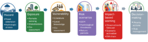
Training activities and programs
WMO RTC ITALY

CLIMATE KNOWLEDGE

The World Meteorological Organization states “Worldwide impacts and costs of adverse climatic events like droughts, storms and floods can be significantly reduced through greater global cooperation and sharing of expertise and data. This calls for a new global ‘framework’ to organize the efficient flow of climate information to all those who need it.”

Experience and mission

CNR IBE that runs the WMO RTC Italy has a long standing and acknowledged experience in conceiving, organizing and delivering training on climate disciplines. RTC Italy’s aims at contributing to the widespread of climate information and knowledge. WMO RTC Italy supports governments, organizations or individuals to cope with climate risks.

TRAINING FOCUS

The RTC Italy training programs (in presence and online) is focused on the impact of climate change on natural resources and agriculture, and also on sub-seasonal to seasonal forecasting and prediction to better manage water resources and agriculture. RTC Italy organises specific training sessions and workshops for projects in African countries

An International Training Initiative to Support the Early Warnings for All Action Plan for Africa.
logo WMO RTC ITALY
Capacity-building initiatives on advanced Meteorology, Climatology and Climate change.
logo WMO RTC ITALY
Training operational Packages for Climate Services. A joint initiative of WMO and CNR-IBE, with the collaboration of IC-CNR.
logo WMO RTC ITALY

Integrated
Projects

Research and Action

Integrated Projects are complex initiatives integrating multiple components including operational services, capacity building activities and research. Bilateral and multilateral integrated projects are sponsored by funding agencies such as the Italian Cooperation, WMO, EU and often co-funded by IBE-CNR.
Photo by Michel Isamuna on Unsplash | Tahoua, Niger

Slapis Sahel Numerical Weather Prediction

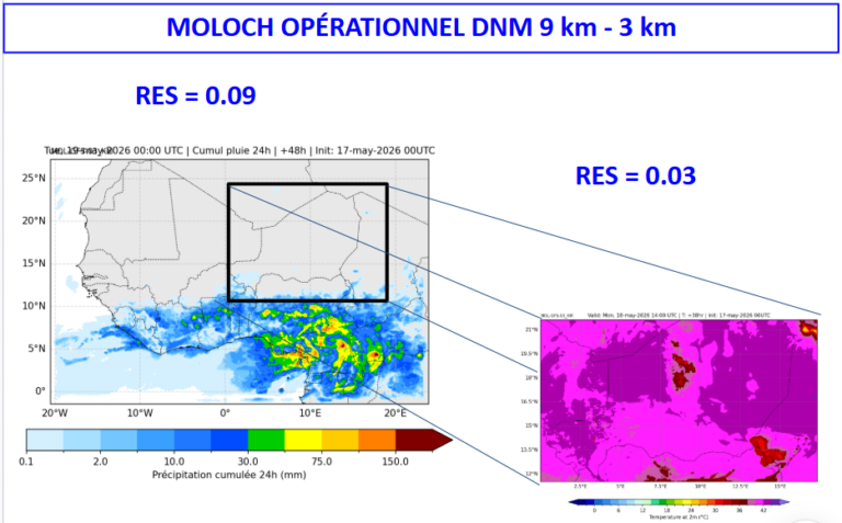
SLAPIS SAHELProject Numerical Weather Predictionin SLAPIS Sahel One of the key objectives of the SLAPIS Sahel project is to strengthen national capacities in Numerical Weather Prediction (NWP) as a support for hydrological early warning, particularly for flash floods and flooding events along the Sirba River and the Niger River. The national

Decorative Image

Slapis Sahel

SLAPIS SAHELProject Système Locale d’Alerte Précoce pour les Inondations au Sahel Slapis Sahel A Training and Research for Development Project The increase in the frequency and intensity of extreme hydro-meteorological events has prompted Sahelian governments to request support from the international community in implementing early warning systems to help vulnerable riverine

Slapis Early Warning System

Attitude proactive pour s’adapter aux changements climatiques et réduire le risque hydrologique dans les Communes de la Sirba.​

Anadia 2.0

Climate Change Adaptation, Disaster Prevention and Agricultural Development for Food Security. A training and research project contributing to the development of sustainable agriculture, through the adaptation of production systems to climate change.

Open Data

Data as a Service

IBE ClimateServices provides full, open and free-of-charge access to data and information, consistent with the international data sharing principles.

The aim is to provide opportunities for the research and the stakeholder community to create a shared sustainable growth to cope with global challenges.

IBE commitment is to foster compliance with OGC (Open Geospatial Consortium) data standards and web services and improve access to data, with a view towards long-term data stewardship.

Henri Poincaré, theoretical physicist

“The scientist does not study nature because it is useful to do so. He studies it because he takes pleasure in it, and he takes pleasure in it because it is beautiful. If nature were not beautiful it would not be worth knowing, and life would not be worth living.”

Climateservices.it
Resources

Shafer, M. (2008).

“Do we, as scientists, need to concern ourselves with whether or how the information is used?”