
From training to transformation: co-producing sustainable early warning competence in West Africa
Operational numerical weather prediction in Sub-Saharan Africa remains fragile despite increasing availability of models and data. A key limiting factor is the limited operational and institutional capacity of National Meteorological Services to operate, assess, adapt, and sustain forecasting chains within routine operations for early warning systems. Short-term, tool-oriented training initiatives often fail to address this […]
INTEGRATED AND IMMERSIVE TRAINING FOR MONITORING CLIMATE EFFECTS ON DIFFERENT ECOSYSTEM COMPOUNDS
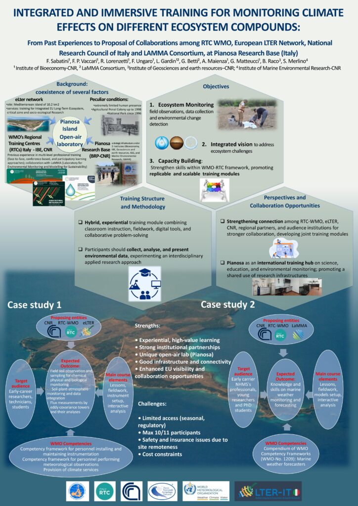
From Past Experiences to Proposal of Collaborations among RTC WMO, European LTER Network, National Research Council of Italy and LAMMA Consortium, at Pianosa Research Base (Italy).
Building Local Capacity through Cascading Agrometeorological Training in Niger A scalable model from the PRIMESA initiative
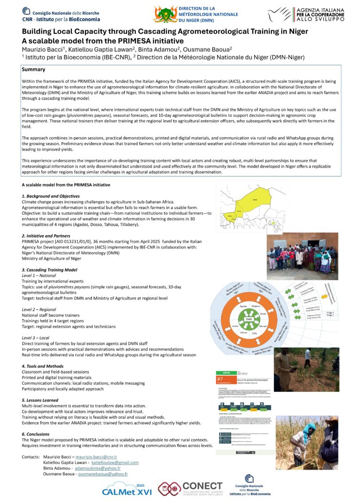
Within the framework of the PRIMESA initiative, funded by the Italian Agency for Development Cooperation (AICS), a structured multi-scale training program is being
implemented in Niger to enhance the use of agrometeorological information for climate-resilient agriculture. In collaboration with the National Directorate of
Meteorology (DMN) and the Ministry of Agriculture of Niger, this training scheme builds on lessons learned from the earlier ANADIA project and aims to reach farmers through a cascading training model.
The program begins at the national level, where international experts train technical staff from the DMN and the Ministry of Agriculture on key topics such as the use
of low-cost rain gauges (pluviomètres paysans), seasonal forecasts, and 10-day agrometeorological bulletins to support decision-making in agronomic crop
management. These national trainers then deliver training at the regional level to agricultural extension officers, who subsequently work directly with farmers in the
field.
The approach combines in-person sessions, practical demonstrations, printed and digital materials, and communication via rural radio and WhatsApp groups during
the growing season. Preliminary evidence shows that trained farmers not only better understand weather and climate information but also apply it more effectively
leading to improved yields.
This experience underscores the importance of co-developing training content with local actors and creating robust, multi-level partnerships to ensure that
meteorological information is not only disseminated but understood and used effectively at the community level. The model developed in Niger offers a replicable
approach for other regions facing similar challenges in agricultural adaptation and training dissemination.
From Training to Transformation: Co-Developing Forecasting Capacities for Early Warning in West Africa
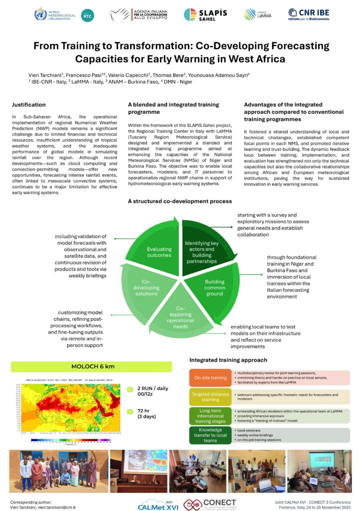
In Sub-Saharan Africa, the operational implementation of regional Numerical Weather Prediction (NWP) models remains a significant challenge due to limited financial and technical resources, insufficient understanding of tropical weather systems, and the inadequate performance of global models in simulating rainfall over the region. Although recent developments—such as cloud computing and convection-permitting models—offer new opportunities, forecasting intense rainfall events, often linked to mesoscale convective systems, continues to be a major limitation for effective early warning systems.
Within the framework of the SLAPIS Sahel project, a development cooperation initiative, the Regional Training Center in Italy designed and implemented a blended and integrated training programme aimed at enhancing the capacities of the National Meteorological Services (NMSs) of Niger and Burkina Faso. The objective was to enable local forecasters, modelers, and IT personnel to operationalize regional NWP chains in support of hydrometeorological early warning systems.
Slapis Sahel Numerical Weather Prediction
SLAPIS SAHELProject Numerical Weather Predictionin SLAPIS Sahel One of the key objectives of the SLAPIS Sahel project is to strengthen national capacities in Numerical Weather Prediction (NWP) as a support for hydrological early warning, particularly for flash floods and flooding events along the Sirba River and the Niger River. The national meteorological agencies of Niger […]
Bridging the communication gap in agrometeorological services: Enhancing the uptake and effectiveness for users in developing countries
Over the past decades, advancements in agrometeorological monitoring and forecasting have been driven by technology, infrastructure, and capacity building. Literature highlights that agrometeorological services support agricultural decision-making, boosting farmers’ resilience and income globally. However, challenges in communication and dissemination limit their effectiveness, particularly for smallholder farmers in remote areas. The problem extends beyond media type […]
Agricultural Meteorology School 5th Edition 2025

Fifth Edition 2025 International School of Agrometeorology Agricultural Meteorologyfor Agriculture Management at Microscale 9-13 June 2025, Ancona, Italy About the Fifth edition Effective agricultural management requires detailed knowledge of microclimatic conditions at the field and sub-field scale. Agricultural Meteorology provides essential tools to monitor and analyse local climate variability, supporting data-driven decisions for resource optimization […]
Les Services Agrométéorologiques pour les producteurs ruraux pour le développement et la durabilité de l’agriculture au Sénégal, Mauritanie, Mali, Burkina Faso et Niger
L’agriculture sahélienne depuis son origine est confrontée à la variabilité climatique qui a caractérisé son développement au cours des millénaires et a conduit les agriculteurs à adopter des stratégies fonctionnelles pour minimiser les risques. Dans la seconde moitié du XXe siècle, l’agrométéorologie s’est développée comme une science appliquée pour soutenir l’agriculture, réduire les risques climatiques […]
Slapis Sahel

SLAPIS SAHELProject Système Locale d’Alerte Précoce pour les Inondations au Sahel Slapis Sahel A Training and Research for Development Project The increase in the frequency and intensity of extreme hydro-meteorological events has prompted Sahelian governments to request support from the international community in implementing early warning systems to help vulnerable riverine communities manage the risk […]