
Flood Risk Knowledge
SLAPIS SAHELProject From flood mapping to informed action An effective Early Warning System must do more than forecast rising water levels. It must also identify what may be affected, where the most serious impacts may occur and which actions should be taken. Within SLAPIS Sahel, flood risk assesment is developed for the Sirba River basin […]
Co-producing a Transboundary Flood Early Warning System
SLAPIS SAHEL Project Working together across borders to protect communities at risk Floods do not stop at national borders. Along the Sirba River, which flows from Burkina Faso into Niger before joining the Niger River, flood waves generated upstream can threaten downstream communities hundreds of kilometres away. Effective flood early warning therefore requires not only […]
The contribution of fine-grained exposure data to flood risk assessment along the Niger River
The establishment of the Sendai Framework for Disaster Risk Reduction 2015‒2030 prompted local governments to prepare flood risk assessments. However, within the rural contexts of low- and middle-income countries, such tools do not account for the details necessary for risk management. Limited data availability is the most frequently reported reason for such deficiencies. Moreover, flood […]
Linking Earth Observation and Precipitation In-Situ Data in the Sirba River Basin in West Africa
Floods have caused substantial loss of life and economic damages in West Africa, with a marked increase of extremes over the past decades. These flood events are largely driven by frequent extreme local rainfall. The sparse meteorological stations in Burkina Faso contain data gaps that limit effective monitoring of rainfall. This study fills the gap […]
A streamlined flood-specific evaluation framework: Assessing African riverine early warning systems
Intense hydrological events are rising across Africa, increasing flood risks. Flood Early Warning Systems (FEWS) are internationally acknowledged as fundamental tools for risk reduction and management. Their effectiveness depends on the integrated and balanced development of all essential components -risk knowledge, monitoring and forecasting, dissemination and communication, preparedness and response-yet their integration across operational systems […]
Competences co-development

SLAPIS SAHEL PROJECT Building operational forecasting capacity through long-term institutional collaboration Early warning systems are based on weather forecasts, numerical models, data platforms and technological innovation. Yet experience shows that technology alone is not enough. The effectiveness and sustainability of early warning services ultimately depend on the ability of institutions to operate, assess, adapt and […]
Dataset on Flood Risk Along the Niger River Upstream of Niamey
Knowledge of river flood risk in semiarid rural areas is often based on outdated, low-resolution geoinformation. Consequently, identification of exposed settlements, assets and risk-reduction measures remains challenging. This dataset provides up-to-date, fine-grained information for a rural area spanning 931 km2 that is exposed to flooding from the Niger River and the Karma Wadi. The dataset includes […]
Mapping precipitation extremes for pluvial flood risk management in the Sirba river basin, Burkina Faso
Sahelian Africa is increasingly exposed to extreme hydrological events. Both fluvial and pluvial floods are becoming more severe and frequent, posing significant new threats to the livelihoods of local communities. To enhance resilience to floods, the development of effective operational tools for assessing risk and supporting decision-making is crucial. When it comes to pluvial floods, […]
From training to transformation: co-producing sustainable early warning competence in West Africa
Operational numerical weather prediction in Sub-Saharan Africa remains fragile despite increasing availability of models and data. A key limiting factor is the limited operational and institutional capacity of National Meteorological Services to operate, assess, adapt, and sustain forecasting chains within routine operations for early warning systems. Short-term, tool-oriented training initiatives often fail to address this […]
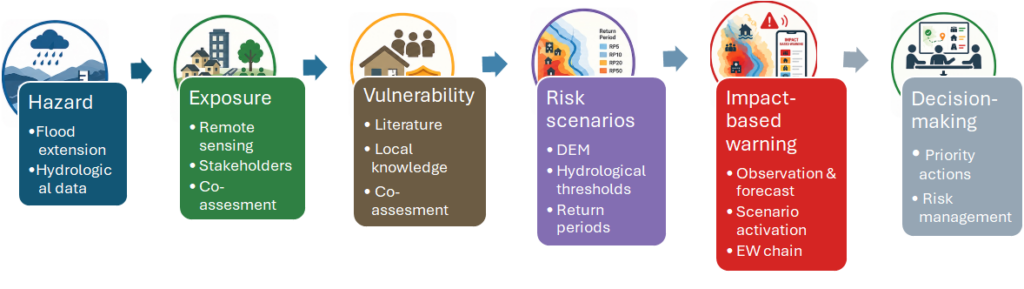
Building Local Capacity through Cascading Agrometeorological Training in Niger A scalable model from the PRIMESA initiative
Within the framework of the PRIMESA initiative, funded by the Italian Agency for Development Cooperation (AICS), a structured multi-scale training program is being
implemented in Niger to enhance the use of agrometeorological information for climate-resilient agriculture. In collaboration with the National Directorate of
Meteorology (DMN) and the Ministry of Agriculture of Niger, this training scheme builds on lessons learned from the earlier ANADIA project and aims to reach farmers through a cascading training model.
The program begins at the national level, where international experts train technical staff from the DMN and the Ministry of Agriculture on key topics such as the use
of low-cost rain gauges (pluviomètres paysans), seasonal forecasts, and 10-day agrometeorological bulletins to support decision-making in agronomic crop
management. These national trainers then deliver training at the regional level to agricultural extension officers, who subsequently work directly with farmers in the
field.
The approach combines in-person sessions, practical demonstrations, printed and digital materials, and communication via rural radio and WhatsApp groups during
the growing season. Preliminary evidence shows that trained farmers not only better understand weather and climate information but also apply it more effectively
leading to improved yields.
This experience underscores the importance of co-developing training content with local actors and creating robust, multi-level partnerships to ensure that
meteorological information is not only disseminated but understood and used effectively at the community level. The model developed in Niger offers a replicable
approach for other regions facing similar challenges in agricultural adaptation and training dissemination.