
Mapping precipitation extremes for pluvial flood risk management in the Sirba river basin, Burkina Faso
Sahelian Africa is increasingly exposed to extreme hydrological events. Both fluvial and pluvial floods are becoming more severe and frequent, posing significant new threats to the livelihoods of local communities. To enhance resilience to floods, the development of effective operational tools for assessing risk and supporting decision-making is crucial. When it comes to pluvial floods, […]
From training to transformation: co-producing sustainable early warning competence in West Africa
Operational numerical weather prediction in Sub-Saharan Africa remains fragile despite increasing availability of models and data. A key limiting factor is the limited operational and institutional capacity of National Meteorological Services to operate, assess, adapt, and sustain forecasting chains within routine operations for early warning systems. Short-term, tool-oriented training initiatives often fail to address this […]
From Training to Transformation: Co-Developing Forecasting Capacities for Early Warning in West Africa
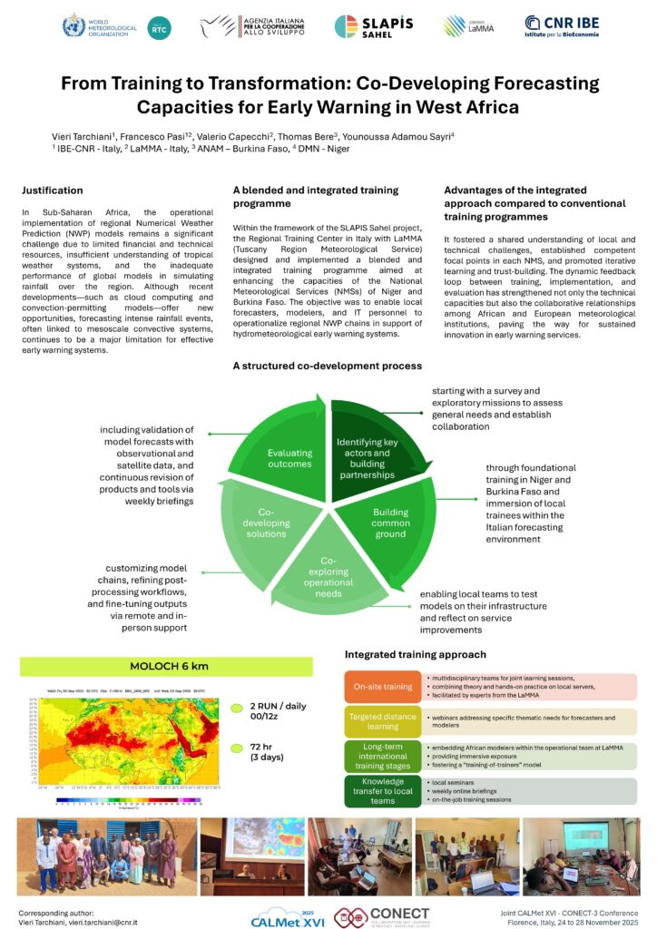
In Sub-Saharan Africa, the operational implementation of regional Numerical Weather Prediction (NWP) models remains a significant challenge due to limited financial and technical resources, insufficient understanding of tropical weather systems, and the inadequate performance of global models in simulating rainfall over the region. Although recent developments—such as cloud computing and convection-permitting models—offer new opportunities, forecasting intense rainfall events, often linked to mesoscale convective systems, continues to be a major limitation for effective early warning systems.
Within the framework of the SLAPIS Sahel project, a development cooperation initiative, the Regional Training Center in Italy designed and implemented a blended and integrated training programme aimed at enhancing the capacities of the National Meteorological Services (NMSs) of Niger and Burkina Faso. The objective was to enable local forecasters, modelers, and IT personnel to operationalize regional NWP chains in support of hydrometeorological early warning systems.
Slapis Sahel Numerical Weather Prediction
SLAPIS SAHELProject Numerical Weather Predictionin SLAPIS Sahel One of the key objectives of the SLAPIS Sahel project is to strengthen national capacities in Numerical Weather Prediction (NWP) as a support for hydrological early warning, particularly for flash floods and flooding events along the Sirba River and the Niger River. The national meteorological agencies of Niger […]
DEM Generation from Multi-View Satellite Images in Sub-Sahel Region
Floods are causing a significant loss of human lives and valuable resources in West Africa. In particular, Niger and Burkina Faso were highly affected areas in past years. In order to predict flood, an accurate Digital elevation model (DEM) is required for flood mapping. At the studied area in Niger, up to this date, the […]
Flood risk assessment of agricultural areas along the Niger river upstream Niamey
Much of the food supplied to the city of Niamey (1.5 million inhabitants), the capital of Niger, comes from 150 large commercial horticultural sites and 10 vast irrigated perimeters distributed along the Niger River upstream of the city. These areas are threatened by floods, such as the one that devastated paddy fields and horticultural areas […]
Flood Damage Risk Mapping Along the River Niger: Ten Benefits of a Participated Approach
Flood risk mapping is spreading in the Global South due to the availability of high-resolution/high-frequency satellite imagery, volunteered geographic information, and hydraulic models. However, these maps are increasingly generated without the participation of exposed communities, contrary to the Sendai Framework for Disaster Risk Reduction 2015–2030 priorities. As a result, the understanding of risk is limited. […]
Compound-event analysis in non-stationary hydrological hazards: a case study of the Niger River in Niamey
This study examines compound hydrological hazards in a non-stationary context, specifically focusing on the Niger River in Niamey. The hazard results from the confluence of local Sahelian and more remote Guinean tributaries, displaying seasonal floods. The study first investigates whether Niamey’s annual flood hazard is a compound result of Sahelian and Guinean flows, and then […]
Geospatial Capacity Building for Flood Resilience in the Sahel: the SLAPIS project case study
This study focuses on the development of a people-centred early warning system (EWS) against floods in the Sirba River basin between Niger and Burkina Faso. This densely populated area has witnessed an increase in extreme flooding events in recent years. Several flood forecasting systems in the Sahel exist, although there is no EWS that integrates […]
Comparative Trend Analysis of Precipitation Indices in Several Towns of the Sirba River Catchment (Burkina Faso) from CHIRPS and TAMSAT Rainfall Estimates
The increasingly frequent pluvial flood of West African urban settlements indicates the need to investigate the drivers of local rainfall changes. However, meteorological stations are few, unevenly distributed, and work irregularly. Daily satellite rainfall datasets can be used. Nevertheless, these products often need to be more accurate due to sensor errors and limitations in retrieval […]