
Building Local Capacity through Cascading Agrometeorological Training in Niger A scalable model from the PRIMESA initiative
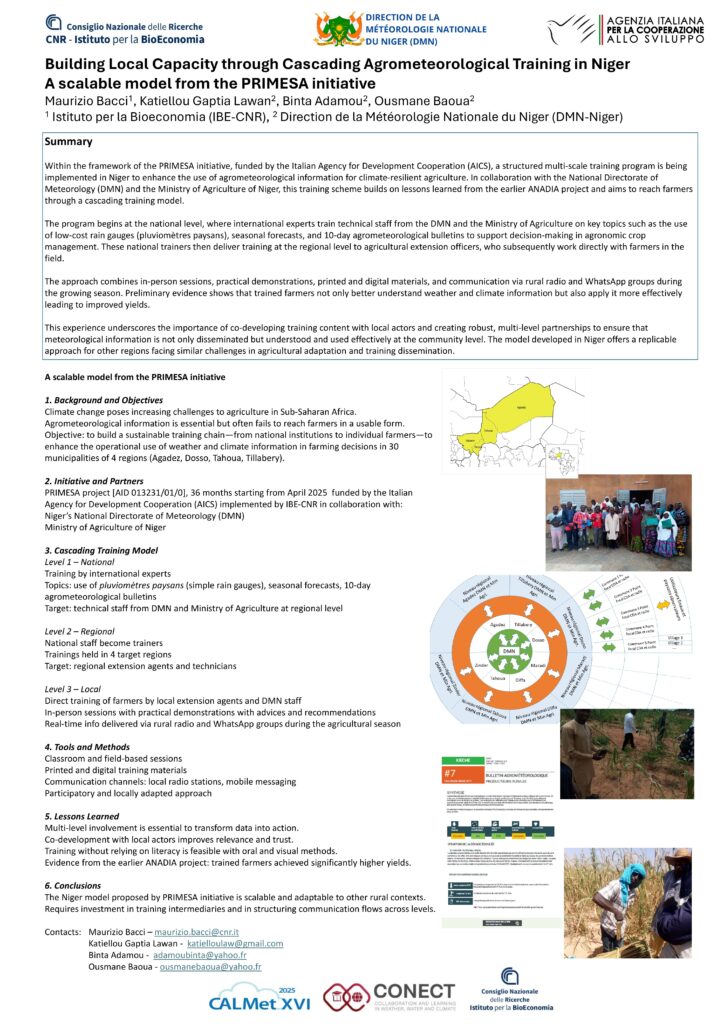
Within the framework of the PRIMESA initiative, funded by the Italian Agency for Development Cooperation (AICS), a structured multi-scale training program is being
implemented in Niger to enhance the use of agrometeorological information for climate-resilient agriculture. In collaboration with the National Directorate of
Meteorology (DMN) and the Ministry of Agriculture of Niger, this training scheme builds on lessons learned from the earlier ANADIA project and aims to reach farmers through a cascading training model.
The program begins at the national level, where international experts train technical staff from the DMN and the Ministry of Agriculture on key topics such as the use
of low-cost rain gauges (pluviomètres paysans), seasonal forecasts, and 10-day agrometeorological bulletins to support decision-making in agronomic crop
management. These national trainers then deliver training at the regional level to agricultural extension officers, who subsequently work directly with farmers in the
field.
The approach combines in-person sessions, practical demonstrations, printed and digital materials, and communication via rural radio and WhatsApp groups during
the growing season. Preliminary evidence shows that trained farmers not only better understand weather and climate information but also apply it more effectively
leading to improved yields.
This experience underscores the importance of co-developing training content with local actors and creating robust, multi-level partnerships to ensure that
meteorological information is not only disseminated but understood and used effectively at the community level. The model developed in Niger offers a replicable
approach for other regions facing similar challenges in agricultural adaptation and training dissemination.
Prototype of a drought monitoring and forecastingsystem for the Tuscany region
A system for drought monitoring and medium–long time forecasting in the Tuscany region (central Italy) is briefly introduced, which is based on ground and satellite data (1km spatial resolution and 16-day temporal resolution). It is also shown how information about current conditions and the future evolution of a drought event is periodically delivered on the LaMMA Consortium website, in collaboration with the Institute […]
Sensor Web Hub

Environmental monitoring data sharing (agrometeo, urban climate, indoor, weather, renewable energy) for decision making.
MedGold
Turning climate-related information into added value for traditional MEDiterranean Grape, OLive and Durum wheat food systems
A Counting Process Approach for Trend Assessment of Drought Condition
This paper discusses some methodological aspects of the historical analysis of drought, particularly the trend assessment. The Standardized Evapotranspiration Index (SPEI) is widely used as a measure of drought condition. Since different SPEI thresholds allow classifying the risk into moderate, severe, and extreme, the drought occurrence becomes a counting process. In this framework, would a […]
Agrosat
Agriculture 4.0, interoperable, free, open and collaborative. Supporting agriculture ecosystem to increase its potential.
Platforme Slapis

Web Platform distributing hydrological information. Slapis was developed in the framework of ANADIA 2.0 project.
Drought Observatory

Operational services for decision-makers, stakeholders, and water managers. Monthly Bulletin (Italy), Indices, and Maps.
Drought Monitoring and Forecasting Services
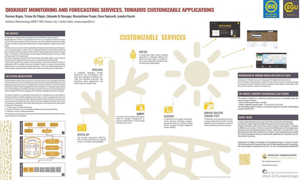
Towards Customizable Applications
Drought Observatory Part 3
Leandro Rocchi