SLAPIS SAHEL
Project
Numerical Weather Prediction
in SLAPIS Sahel
One of the key objectives of the SLAPIS Sahel project is to strengthen national capacities in Numerical Weather Prediction (NWP) as a support for hydrological early warning, particularly for flash floods and flooding events along the Sirba River and the Niger River.
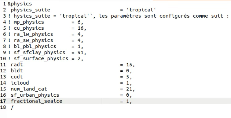
The national meteorological agencies of Niger (DMN) and Burkina Faso (ANAM) strategically decided to develop NWP chains based on the Weather Research and Forecasting (WRF) model. WRF is a widely used regional model for both operational weather forecasting and research, developed primarily by the National Center for Atmospheric Research (NCAR) in the United States.
To this end, Niger and Burkina Faso receive support from IBE-CNR and, through it, from the LaMMA Consortium — joint initiative between CNR and the Tuscany Region, which provides regional meteorological services in Italy.
Capacity Building Timeline
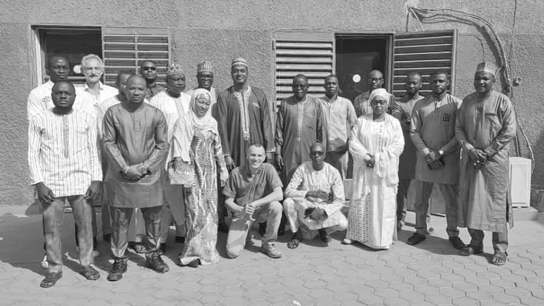
In the framework of SLAPIS Sahel project, a series of capacity building actions were carried out to build local expertise on WRF and numerical forecasting.
Niamey (Niger)
Capacity building for the staff of the Direction de la Météorologie Nationale in Numerical Weather Prediction.
Duration: 5 days — Participants: 15 (Niger)
Niamey (Niger)
Action-based training: Performance and tuning of the Weather Research and Forecasting (WRF) model.
Duration: 4 days — Participants: 24 (Niger and Burkina Faso).
Florence (Italy)
Long-term training on Numerical Weather Prediction for early flood warning.
Duration: 12 months — Participants: 2 (Niger and Burkina Faso)
Ouagadougou (Burkina Faso)
WRF product validation workshop.
Duration: 1 day — Participants: 12 (Burkina Faso)
Niamey (Niger)
WRF product validation workshop.
Duration: 1 day — Participants: 18 (Niger)
Niamey (Niger)
Rainfall estimation merging and operational integration of WRF Workshop. Duration: 1 day — Participants: 7 (Niger)Webinar
Action-oriented seminar on the MOLOCH operational model.
Duration: 1 day — Participants: 14 (Niger and Burkina Faso)
Webinar
Presentation of the web interface for accessing operational MOLOCH and WRF forecasts.
Duration: 1 day — Participants: 7 (Niger and Burkina Faso)


Operational Forecasting Chains
The establishment of operational NWP systems in Niger and Burkina Faso stands as a concrete result of SLAPIS Sahel. Tailored to national needs, the two chains strengthen local forecasting capabilities and support early warning efforts.
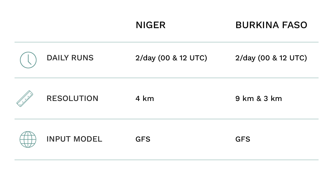
Since 2018, ANAM has been developing its WRF-based forecast chain through initiatives such as the HYDROMET Project (World Bank) and CREWS Project (WMO). Since June 2023, WRF (ARW) has been operational in Burkina Faso with two runs per day at 9 km and 3 km resolutions.
Model Evaluation & Verification
Methodology
Due to different configurations and the absence of systematic evaluation, a verification process was initiated in collaboration with LaMMA and supported through two research fellowships in Florence.
Historical forecasts (hindcasts) were generated for July–August–September 2023 and 2024, comparing WRF-Niger, WRF-Burkina, and GFS.
Simulations were run on an 8-node Intel Xeon Gold 6130 cluster (256 cores total) with the latest WRF version. The simulation domain covered Niger, Burkina Faso, extended southward to the Gulf of Guinea and eastward to Chad. Initialization data were sourced from the GFS global model, and 36-hour simulations were launched from 18 UTC. The initial 6-hour spin-up period was excluded from the analysis. Comparisons were performed using both satellite estimates (00h–00h accumulation) and station data (06h–06h accumulation).
Results
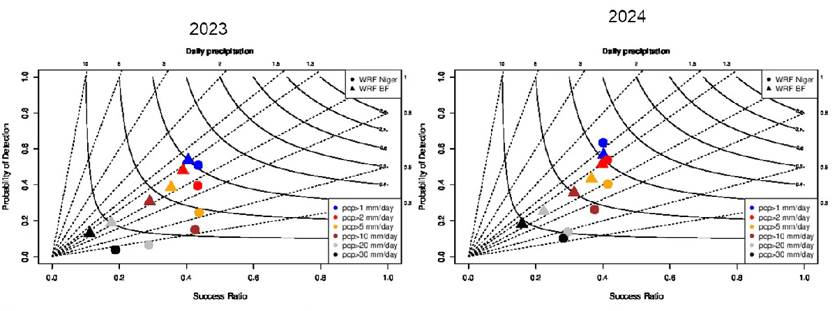
Deterministic Metrics (ME, MAE, Correlation)
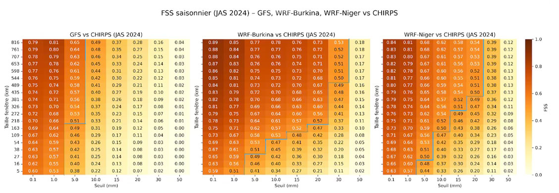
Fraction Skill Score (FSS)

Case Study Analysis
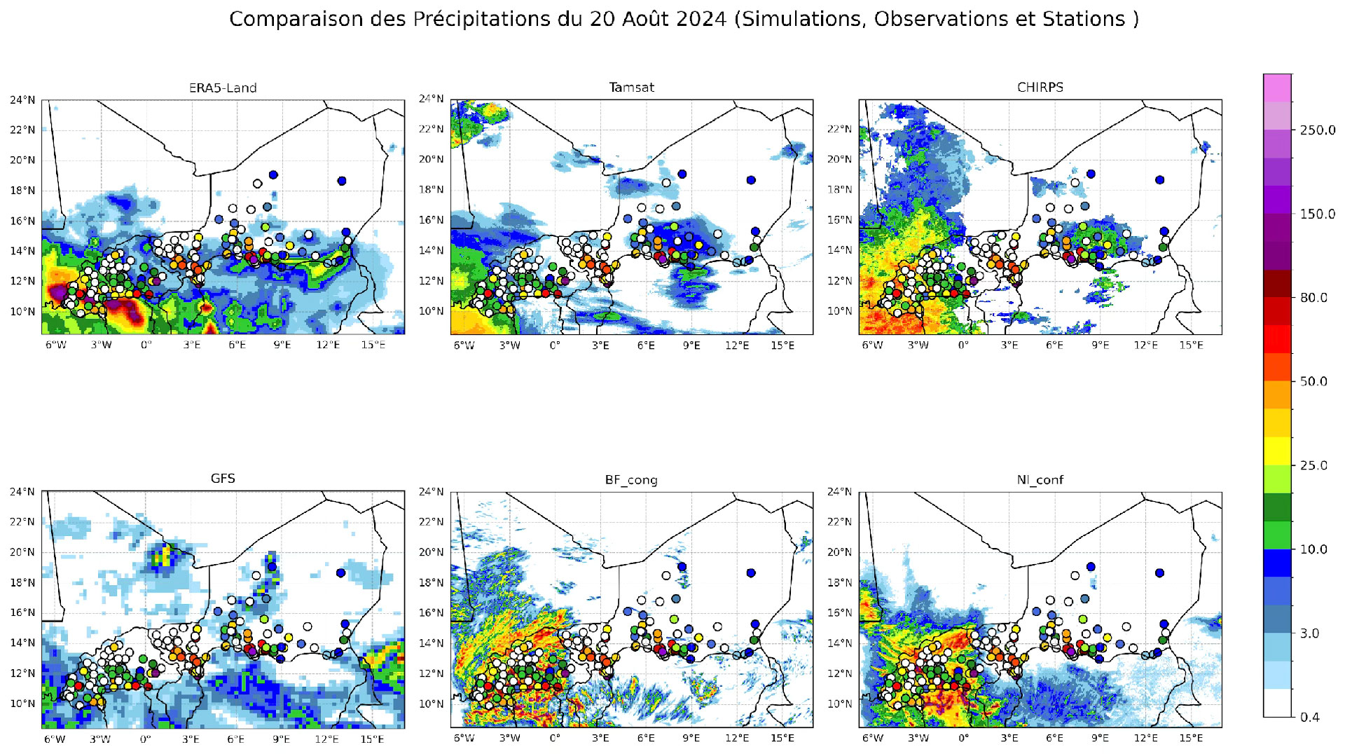
The verification included specific case studies — such as the events of 20 and 30 August 2024 — to illustrate how the models performed under particular meteorological conditions. These cases (Figure 3) were used to assess the models’ ability to capture the spatial and temporal characteristics of precipitation, with a focus on convective rainfall.
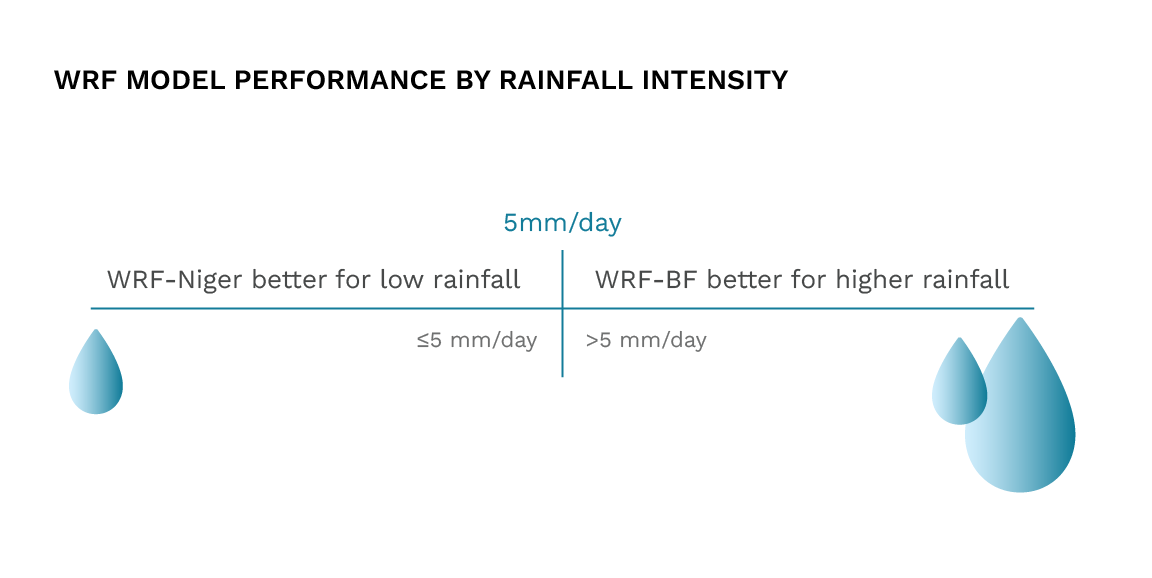
General Comparison
Future Perspectives
Parallel Backup Chain and MOLOCH
In order to ensure a backup forecasting chain in case of outages affecting the operational systems of Niger and Burkina Faso during the rainy season, a parallel WRF chain was implemented on LaMMA’s cluster, using the same configuration adopted by DMN.
What is Moloch?
Model Overview
MOLOCH (MOdel LOCal H-coordinates) is a non-hydrostatic, convection-resolving numerical weather prediction model developed by the Institute of Atmospheric Sciences and Climate (CNR-ISAC) and used by the LaMMA Consortium. It features an Arakawa C-grid, a hybrid terrain-following coordinate system, and updated radiation and soil schemes. The microphysics scheme includes five hydrometeors and does not use graupel parametrization, unlike some WRF schemes.
Technical Configuration
– CORE: Non-hydrostatic, fully compressible, convection-resolving
– GRID: Arakawa C-grid, latitude-longitude, hybrid terrain-following
– RADIATION: ECMWF scheme (updated 2024)
– TURBULENCE: E–L Kinetic Energy, 1.5-order closure
– SOIL: 6-level DROPA scheme
– CUMULUS SCHEME: Kain-Fritsch
Applications
MOLOCH is widely used for temperature and precipitation forecasts in Italy, Spain, and Greece. The latest version is available on GitLab:
🔗 https://gitlab.com/isac-meteo/globo-bolam-moloch
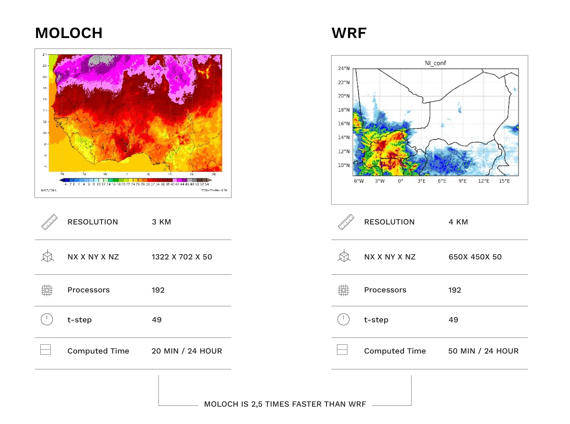
In addition, an operational MOLOCH chain (what is MOLOCH? see box above) was also deployed to provide numerical forecasts for West Africa. As a dedicated test comparing MOLOCH and WRF in the region showed that MOLOCH is two to three times faster than WRF.
Moloch as Innovative Solution
The deployment of MOLOCH in the Sahel is one of the innovative aspects of this study: the model has traditionally been used in mid-latitude regions (Davolio et al., 2020), and very few attempts had previously been made to run it in tropical environments using explicit convection schemes.
Thanks to its faster runtime, MOLOCH was able to simulate a wider domain covering all of West Africa at a spatial resolution of 3 km.
click the image to enlarge
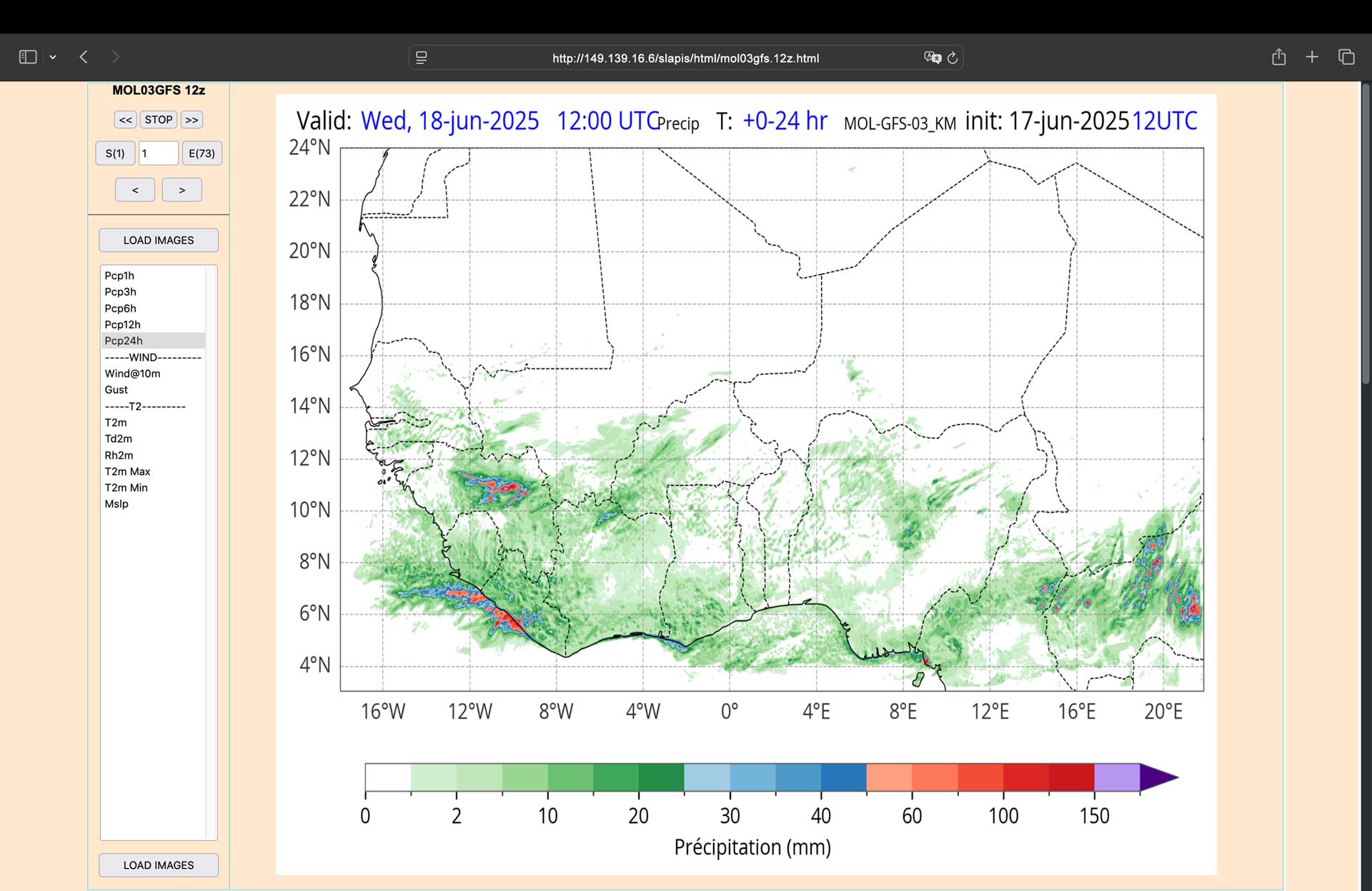
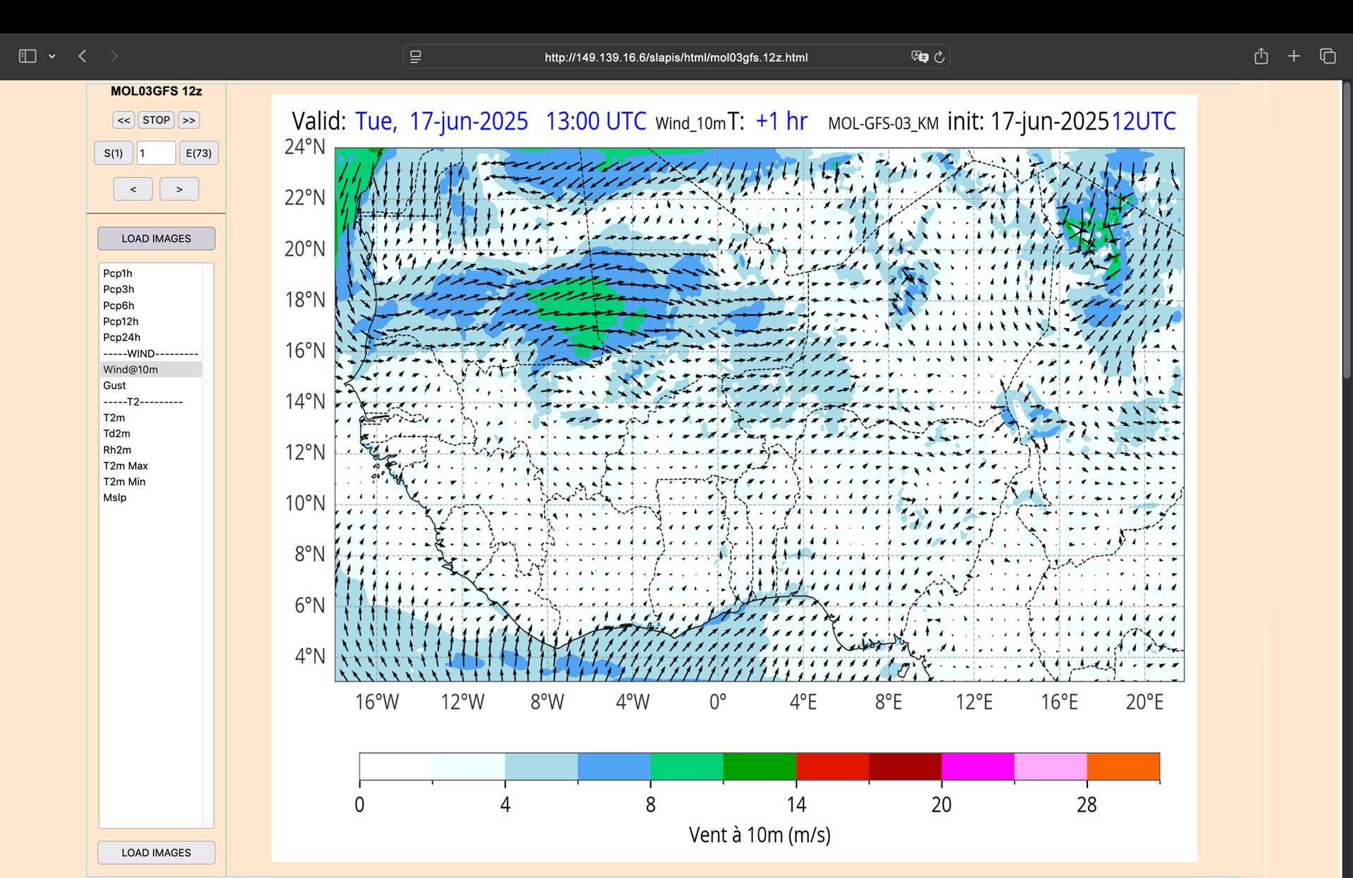
Forecast Products & Visualization Tools
A web interface was developed to visualize outputs from both WRF and MOLOCH. This tool is available to DMN and ANAM forecasters to support daily operations and gather feedback on content and format improvements.
- Model Output Viewer
This section provides access to the outputs of the WRF and MOLOCH models.
Currently, both models are initialised using data from the GFS (Global Forecast System). Two forecast runs are available per day: one at 00 UTC and one at 12 UTC.
In the near future, additional forecast chains based on ECMWF Open Data are planned to be implemented. - Archive Access
Archived model outputs are available both as images and in GRIB format. These resources are intended to support daily bulletins as well as verification analyses and retrospective studies. - Model Evaluation
This section will collect performance assessments of WRF and MOLOCH, comparing model outputs with observed data from in-situ stations or satellite sources.
At the bottom of the page, a table summarises key characteristics of the two models, including resolution, microphysics schemes, convection treatment, domain, and input data sources.