Flood risk is increasing rapidly in the Sahel due to the combined effects of intensifying rainfall, land-use and land-cover changes, and growing exposure of populations and assets. In such contexts, early warning systems are increasingly expected not only to detect hazards, but to support risk-informed decision-making. However, in data-scarce and high-uncertainty environments, conventional flood risk assessment and modelling approaches often fail to provide operationally meaningful guidance for local authorities.
The methodological approach implemented by the project SLAPIS Sahel, has been presented at the Annual Conference of the European Society for Risk Analysis held in Alicante, Spain on mai 27-29, 2026.
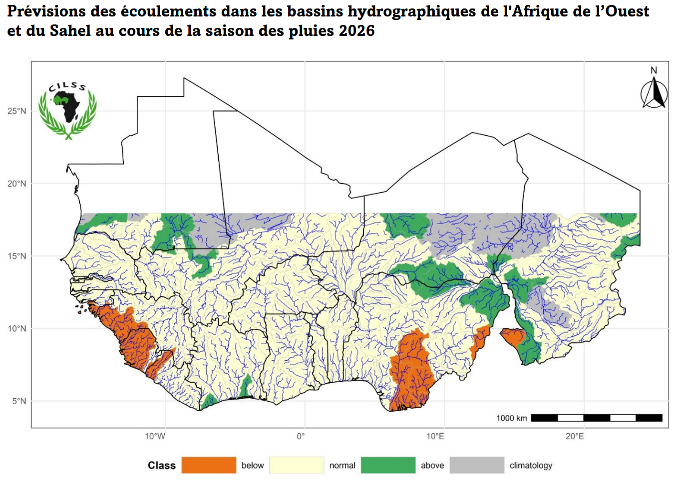
This contribution presents the methodological framework developed within the SLAPIS Sahel initiative for linking participatory flood risk assessment to impact-based early warning and local decision-making. The approach was implemented in the Sirba River basin and along the upstream Niger River affecting the city of Niamey, in Niger and Burkina Faso, and is designed to operate under conditions of limited observations, restricted field access, and institutional and security constraints.
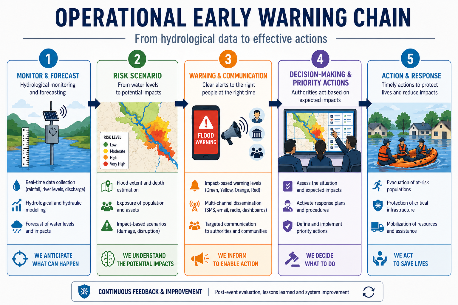
The core methodological contribution lies in the use of spatially explicit risk scenarios as an intermediate layer between hazard modelling and operational warning decisions. Participatory risk assessment was used to jointly define flood hazard, exposure of critical assets, and vulnerability with local stakeholders. These components were integrated into a set of spatialized risk scenarios associated with multiple return periods. Rather than serving solely as analytical outputs, these scenarios function as boundary objects connecting scientific modelling with governance processes, allowing the explicit translation of hydrological thresholds into potential risk levels.
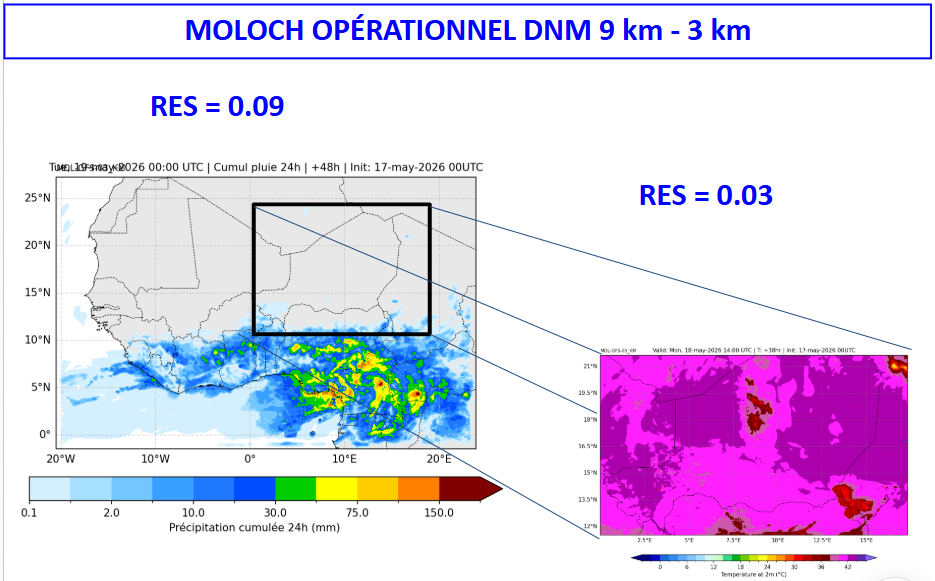
Observed and forecast river discharges are evaluated against these thresholds to trigger warnings that are directly linked to expected impacts and, eventually, priority actions. This structure enables decision-makers to move from hazard-based alerts to risk-informed choices, supporting the prioritisation of interventions, allocation of limited resources, and clearer accountability in warning issuance. Advanced hydrological and hydraulic modelling and satellite-based observations were combined with participatory inputs to mitigate data gaps and to concentrate modelling efforts on highly exposed settlements and critical infrastructure, while reducing complexity in low-risk rural areas.
The framework proved effective in supporting early stakeholder engagement, facilitating field validation of risk maps, capturing the heterogeneity of flood impacts, and simplifying the operationalisation of impact-based flood warnings. At the same time, limitations remain in representing the social dimensions of vulnerability, particularly where flood risk interacts with insecurity and conflict. These constraints highlight the need for further integration between risk modelling and social risk governance.
Overall, the SLAPIS Sahel experience demonstrates how simplified, participatory, and scenario-based risk assessment can be operationalized to support impact-based early warning and decision-making in fragile, data-limited contexts. The proposed framework offers transferable methodological insights for flood risk assessment and governance beyond the Sahel, particularly in regions facing similar constraints.