

Flood Risk
Knowledge
Slapis Sahel
Project
SLAPIS SAHEL
Project
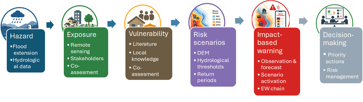
From flood mapping to informed action
An effective Early Warning System must do more than forecast rising water levels. It must also identify what may be affected, where the most serious impacts may occur and which actions should be taken.
Within SLAPIS Sahel, flood risk assesment is developed for the Sirba River basin and the Niger River between the Sirba confluence and Niamey. This area includes rural settlements, river islands, irrigated fields, horticultural sites, roads, wells and other infrastructure that support local livelihoods. The aim is to transform scientific and local knowledge into practical information for preparedness, impact-based warning and risk reduction planning.
Understanding the different sources of flood risk
The project area is affected by different types of flooding. During the rainy season, rainfall over the Sirba basin and other Sahelian tributaries contributes to the local flood of the Niger River. Later in the year, water arriving from the upper Niger basin generates the slower and longer-lasting Guinean flood. Moreover, intense rainfall can produce flash floods (pluvial floods). These floods produce different impacts. Local floods may rise quickly, while Guinean flood can keep fields and settlements inundated for several weeks. Flood duration can therefore be as important as maximum water level, especially for crops and adobe buildings.
Combining science, field evidence and local knowledge
Flood risk assessments bring together:
- river discharge and rainfall observations;
- hydraulic modelling;
- satellite imagery and digitale elevation models;
- detailed mapping of buildings, crops and infrastructure;
- field surveys and ground validation;
- knowledge from communities, municipalities and technical services.
This approach improves the accuracy of flood maps and helps identify features that conventional datasets often overlook, such as traditional rice fields, horticultural areas, adobe houses, wells and small rural settlements. Local actors also help explain how floods actually occur, where embankments fail, how long water remains and which activities suffer the greatest damage.
Mapping FLOOD PRONE AREAS
Flood-prone areas are identified by combining hydrological observations, hydraulic modelling and Earth observation data.
Historical river discharge records are first analysed to estimate floods with different probabilities of occurrence. These flood scenarios are then simulated using the two-dimensional hydraulic model BASEMENT (ETH Zurich), which reproduces how water propagates across the river corridor under different flow conditions. The simulations are based on Digital Elevation Models (DEMs) derived from satellite missions, complemented by information on river geometry and land surface characteristics.
The resulting flood extent and water depth maps are validated against observed flood footprints extracted from Sentinel-2 satellite imagery and field observations, ensuring that the simulated inundation areas closely represent real flood events. These hazard maps provide the scientific basis for identifying exposed assets, assessing flood impacts and developing Flood Risk Scenarios for impact-based early warning.
Mapping exposure and expected impacts
SLAPIS Sahel does not stop at identifying flooded areas. It maps the assets located within them and estimates the potential damages. The assessments consider:
- settlements and individual buildings;
- irrigated and traditional agriculture;
- critical infrastructures such as wells, boreholes and public infrastructure;
- seasonal changes in land use and crop value.
The 2024–2025 floods showed that large areas of cultivated land were affected and that traditional rice and horticulture were among the most exposed activities. The studies also confirmed that prolonged flooding can cause severe losses even when peak water levels are not exceptional.
From risk knowledge to Flood Risk Scenarios
Flood risk assessment becomes truly operational when it is translated into Flood Risk Scenarios.
A Flood Risk Scenario combines information on the expected flood hazard with detailed knowledge of exposed items and their vulnerability. Rather than simply describing where water may reach, it anticipates what is likely to happen under different flood conditions and identifies the corresponding impacts.
Within SLAPIS Sahel, flood risk scenarios provide the operational link between hazard monitoring and impact-based early warning. As forecasts and river observations indicate the evolution of a flood event, the corresponding scenario helps emergency managers anticipate the expected consequences, identify the most exposed areas and communicate targeted warning messages together with appropriate preparedness and response actions. In this way, scientific forecasts are transformed into actionable information that supports timely decision-making by institutions, emergency services and communities. Toutes les informations produites sont accessibles à travers la Plateforme SLAPIS Sahel et le catalogue de données ouverts.
Supporting prevention and local planning
Flood risk information is also used to identify appropriate risk-reduction measures. Depending on water depth, duration and local conditions, these may include:
- municipal contingency plans and evacuation procedures;
- flood-zone marking and land-use regulation;
- temporary barriers and sandbags;
- protection or raising of wells and sanitation facilities;
- settlement barriers;
- relocation of horticulture or future settlement expansion to safer land;
- resettlement where protection is not feasible.
The measures are discussed with local stakeholders and assessed according to feasibility, cost, maintenance needs and community acceptance.